Nathan Rao on Facebook Nathan Rao on Twitter

Met Office

Hurricane Gert to save summer?


A TROPICAL hurricane currently swirling off the coast of America could save Britain's summer, forecasters say.

Hurricane Gert, now a category-1 storm tearing through the Atlantic at 85mph, is about to head this way.

But rather than hit the UK bringing up wind and rain, the storm is forecast to head north missing  country entirely.

It will form a deep area of low pressure off the northern tip of Scotland pulling high pressure up from the Continent and the Azores.

Met Office warns of 24-hour deluge

TORRENTIAL downpours will put parts of Britain on flood alert with a month’s rain forecast over the next 24 hours.

Exposed and coastal regions are braced for chilly 50mph gales as Icelandic winds put the blazing start to summer on hold.

Temperatures will take a plunge around the country as weatherman warn the weather is about to “go downhill”.

The Met Office has warned of an “unpleasant week” ahead with nowhere likely to escape almost autumnal conditions.

"Major" Arctic blast on way

BRITAIN is on alert for a “major” Arctic freeze to bring sub-zero temperatures and snow after the weekend.

Icy gales threaten blizzard conditions in parts of the country with widespread hail and sleet forecast.

Snowfall will hit Scotland and high ground across northern England early next week before hail and sleet nudge further south, experts say.

The snow risk will escalate into next weekend with heavy flurries possible across Wales and central England.

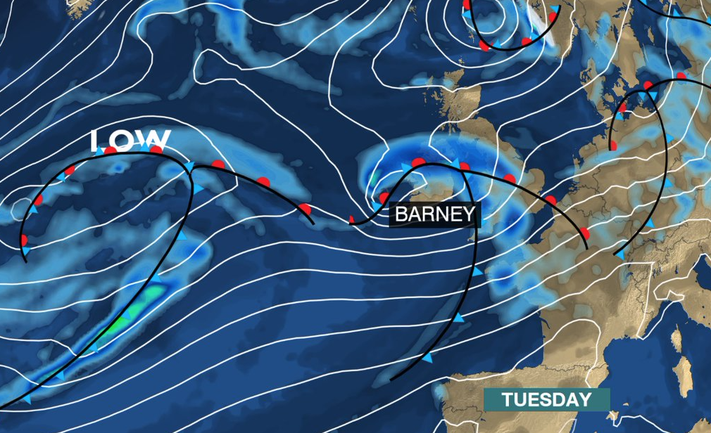
Storm Barney to hammer southern Britain on Tuesday

The Met Office said severe gales of up to 80mph on Tuesday across the south will give rise to the second named storm of the season.

A severe weather warning for wind has been issued across the region as ‘Barney’ sweeps in from the Atlantic.

Gales of 60mph are expected widely while coastal gusts could top 80mph as the storm rips through Britian during hte afternoon and into the night.

Met Office gives weather-watchers the chance to name this year's storms

IT’S that time of year again - the evenings are getting darker and the Atlantic is firing up for the run of storms which usually arrives in autumn.


So far it’s been relatively quiet. This time last year  Bertha had already unleashed mayhem, then Cristobal warmed things up before Gonzalo whipped his tail across our fair isles.


We are not unused to some pretty powerful monsters tearing across the country around September/ October time - remember the St Jude Day battering of 2013.


Christmas Weather and 'that' storm

No papers tomorrow so here’s the very latest outlook for Christmas Day and that storm which threatens unsettled conditions on Friday.

Most of us will wake to a crisp and sunny day tomorrow but unfortunately no snow, I believe the correct term is a ‘green Christmas’.

However, if you’ve put money on the white stuff all may not be lost, there is the chance of the odd flurry over high ground in the north - so fingers crossed.

Is there ANOTHER ex-hurricane on the way this month?

BRITAIN could be looking at another hammering from the elements with the “seeds” of yet more tropical storms currently sprouting near the Atlantic.

Forecasters last night said they have spotted signs of a “hurricane-force” storm brewing off the coast of Africa threaten to  disrupt Britain’s calm autumn weather later this month.

If it develops it is likely to swing northwards with Europe and the UK in the firing line in around 10 to 12 days, they added, though said it is far too early to start panicking.