


A TROPICAL hurricane currently swirling off the coast of America could save Britain's summer, forecasters say.
Hurricane Gert, now a category-1 storm tearing through the Atlantic at 85mph, is about to head this way.
But rather than hit the UK bringing up wind and rain, the storm is forecast to head north missing country entirely.
It will form a deep area of low pressure off the northern tip of Scotland pulling high pressure up from the Continent and the Azores.
The result will be clearer skies and the chance of warm sunshine with experts claiming Gert could “save our summer”.
Jim Dale, forecaster for British Weather Services, said: “Gert is likely to get picked by the jet stream and steered towards the UK and this might be part of he equation that will eventually bring a change to our weather.
“What’s left of the hurricane will move over the north of the country helping high pressure to build across the UK.
“The Azores High and the Continental High will push up towards the country and this could bring the expected improvement in the weather for the end of the month.”
He said the jet stream, which has been stuck to the south of Britain over the past few weeks, is starting to move northwards.
This will allow warmer air from the south to nudge into Britain while putting the remnants of Gert on track to reach the north Atlantic at the start of next week, he added.
He said: “There is a chance that what’s left of Gert could rescue summer; once it gets close to Newfoundland it will turn the corner and get caught up in the jet stream.
“It will not arrive as a hurricane but as an area of low pressure helping high pressure to build over England and northern Europe.
“it will coincide with what we have already been saying and that is that there is likely to be an improvement in our weather towards the end of August.
“This will boost what is already expected to happen.”
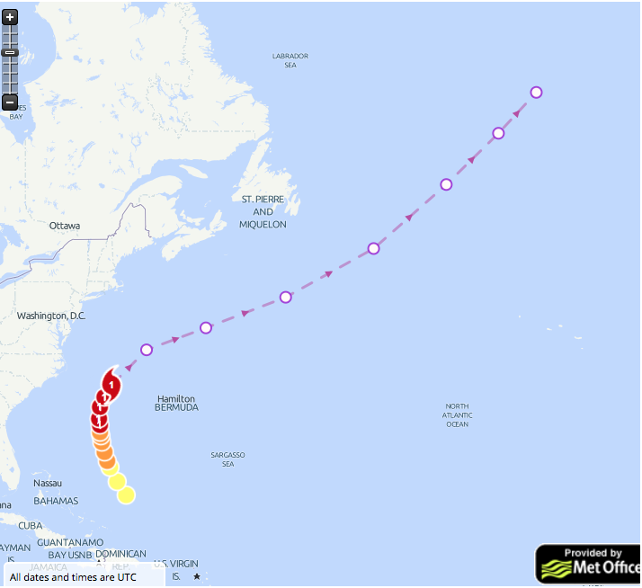
The Met Office said by the time Gert reaches the UK it will have weakened into a deep low pressure system.
What’s left of the hurricane will brush the tip of Scotland before moving into the north Atlantic bringing warm, unstable air to the region,
Met Office spokesman Grahame Madge said: “Gert will be modified as it moves our way and makes its way towards the north Atlantic.
“When it arrives it will bring warm air and temperatures will rise feeding extra energy into this system.
“However there is a good chance that another effect will be that the Azores High will build and then extend across the UK, this will also encourage low pressure to move away.
“However it is important to note that what we will be seeing by the time this reaches us is the air that was associated with Gert, and not a hurricane.”
The US National Hurricane Centre said the hurricane is showing signs of strengthening over the next few days as its path changes.
It warned coasts in some northeastern American States will be battered by large waves as the storm pulls up a colossal sea swell.
A spokesman said: “Gert has an opportunity to gather some strength in the next day or so after
recurvature.
“After two days, Gert will be completely embedded within the mid-latitude westerlies and should become a post-tropical cyclone.
“The cyclone should then turn to the northeast with an increase in forward speed later today
as it becomes embedded within the mid-latitude flow.
“Swells from Gert are expected to spread northward along the mid-Atlantic coast of the United States during the next few days.
“These swells are likely to produce dangerous surf and rip current conditions.”